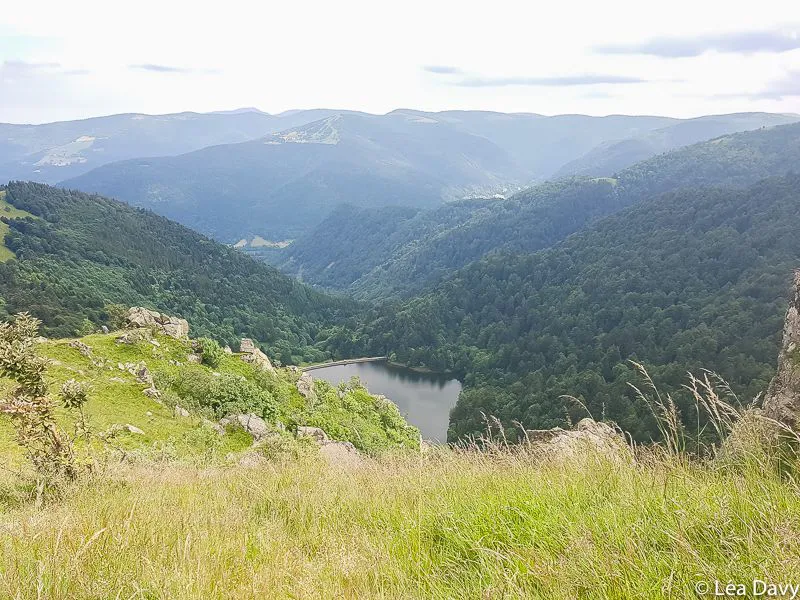
Hike from Hohneck to the Frankenthal-Missheimle nature reserve

Flowery meadows, shady forests, winding and steep paths, a magnificent panorama of the Vosges... This is the program of this Hike to the Hohneck! This 11km loop hike (5h), which passes through the Frankenthal-Missheimle nature reserveThis is a great opportunity to discover the diversity of the landscapes you will cross... And its sporty side!

Warning: this hike takes part of the Sentier des Roches, a rather difficult path on the side of the mountain. Some passages can be delicate for people sensitive to vertigo. Every year, the rescue services intervene in accidents, even among the most experienced hikers. So be careful! A good equipment is essential, the hike is not recommended in case of rain and impracticable in winter. I don’t want to scare you, just to alert you on the minimal precautions to take 🙂 Another tip: we found the itinerary of this hike on Visorando, I also advise you to use this application to avoid missing a junction or to follow the wrong signs.
Departure from the summit of the Hohneck
The hike starts at an altitude of 1,363 meters, on the parking lot of the hotel restaurant Au Sommet du Hohneck. This one lives up to its name: there is a magnificent view of Alsace on one side and Lorraine on the other.
Then follow the blue ring or the Lake Schiessrothried signs to a small intersection. Attention: do not miss the beginning of the path that goes down to the lake (marked with a blue triangle). It can easily be missed because it is quite narrow, steep and rocky. It will take you down, down and down to the Schiessrothried lake. A rather physical passage but which has charm, encased in the middle of the vegetation.
From the lake to the fern meadow
The rest of the way to the lake is less demanding once you enter a forest (and therefore in the shade!). You will come out at the dam of the Schiessrothried lake, which you have to cross. If you feel like it, you can dip your feet in for a refreshing break 🙂 Then take a wide forest road, marked with a red rectangle, heading northwest after the dam.
You will soon come to an intersection, where you will have to turn towards a very pretty meadow covered with ferns (blue rectangle markers). After a passage in a charming undergrowth, you will continue the hike in the shade of the forest to the place called Gaschney.
Finding the next part of the route is not easy because you have to find a forest path nestled between two chalets (blue rectangle markings). Once this challenge is met, you will reach a small open space with picnic tables in a few minutes. It’s time to have lunch or to take a break because in a little kilometer the path becomes too narrow and on the side of the mountain, in short, not the ideal to stop for a long time.
From the Rocks Trail to the Frankenthal Nature Reserve
Here is the Sentier des Roches. This is not the most difficult part of the path but again, be careful! The path, with beautiful views of the valley on one side and a tangle of monumental stones and vegetation on the other, has a lot of charm but keep a careful eye on where you step!
You will soon come to a crossroads indicating the Frankenthal inn. You can go there and back, just to have a drink or a bite to eat, it will take you 30 minutes at the most and the path is very nice (but narrow and slippery so be careful!).
Alternatively, take the marked red rectangle path which will take you continuously up to the Frankenthal-Missheimle National Nature Reserve. Enjoy the beautiful views that nestle on this last part of the hike. At the end of this climb, maybe even cows will be waiting for you!
Enjoy the 360-degree view and then the hike ends by taking the direction of the Hohneck summit (red rectangle markers).
I liked
- The diversity of landscapes
- The sporty side of hiking
- The charm of the Sentier des Roches
I liked less
- The Sentier des Roches is quite well known, therefore, it is crowded!
My photos of the hike to the Hohneck


Practical information
Itinerary
The Visorando application allows you to download the route of this hike and to follow your progress in real time thanks to the geolocalization of your smartphone. Here is the route via Visorando.
Departure and arrival
At the top of the Hohneck, parking of the hotel restaurant.
Features
- Distance : 11 km
- Difference in altitude: 550 meters approximately
- Duration : 5h without counting the picnic
Access
By car
We have to go to Sondernach. Count it:- 43 km from Colmar (about 1 hour)
- 65 km from Mulhouse (about 1h15))
- 115 km from Strasbourg (about 2 hours)

